Search results
Jump to navigation
Jump to search
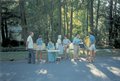
File:Pinecrest 01.web.jpg ...est Road Neighborhood]] residents, presumably at an [[Annual Old Pinecrest Road Block Party|annual block party]], circa 1986(1,531 × 1,034 (201 KB)) - 11:03, 8 July 2009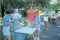
File:Pinecrest 04.web.jpg ...est Road Neighborhood]] residents, presumably at an [[Annual Old Pinecrest Road Block Party|annual block party]], circa 1986(640 × 433 (116 KB)) - 21:37, 30 July 2007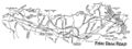
File:smallmap6.jpg * '''what''': map of [[Fish Dam Road]](1,443 × 536 (148 KB)) - 18:17, 1 June 2014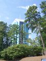
File:100 6072.JPG ...sity Tower]] -- a view from closer to [[US/NC/Durham/roads/Pickett|Pickett Road]](1,932 × 2,576 (1.59 MB)) - 20:54, 29 August 2011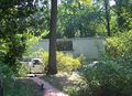
File:100 6092 2719 McDowell.crop.web.JPG [[US/NC/Durham/roads/McDowell/2719|2719 McDowell Road]] - cropped and downsized version of [[htwiki:File:100 6092.JPG|this photo](1,280 × 924 (607 KB)) - 18:47, 29 August 2011
File:100 6089.JPG ...tecat|2011-08-29}}the 2700 block of [[US/NC/Durham/roads/McDowell|McDowell Road]] on {{date|2011-08-29}}(2,576 × 1,932 (1.51 MB)) - 20:06, 29 August 2011
File:Final-Published Attachment - 11812 - MEMO - EB-4707B OLD DURHAM-CHAPEL HILL RO.pdf ...onstruction of Bicycle and Pedestrian Facilities on Old Durham-Chapel Hill Road (TIP #EB-4707B)(0 × 0 (106 KB)) - 10:12, 16 May 2017File:ATT Update 2010-10-22.pdf ...ssing [[American Tobacco Trail/I-40|section between NC54 and Massey Chapel Road]](0 × 0 (67 KB)) - 11:24, 28 October 2010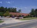
File:100 6073.JPG ...ity]] building at the corner of [[US/NC/Durham/roads/Cornwallis|Cornwallis Road]] and [[US/NC/Durham/roads/Tower|Tower Boulevard]]{{datecat|2011-08-29}}(2,576 × 1,932 (977 KB)) - 22:12, 29 August 2011


