Difference between revisions of "American Tobacco Trail/I-40"
(update -- bridge now open) |
(Jack Warman's night/lighting photo) |
||
| Line 1: | Line 1: | ||
| + | [[File:Jack-Warman-ATT-bridge.jpg|thumb|the bridge at night, showing newly-installed lighting]] | ||
==Navigation== | ==Navigation== | ||
* '''north''': {{l/same|south Durham}} | * '''north''': {{l/same|south Durham}} | ||
Latest revision as of 18:48, 10 April 2014

- north: south Durham
- south: south of I-40
About
The crossing over I-40 was the major obstacle, for many years, to having a contiguous American Tobacco Trail, but the long-awaited pedestrian bridge was finally opened on 2014-02-20, connecting the south Durham stretch with the stretch south of I-40, itself completed in 2013.
The pedestrian bridge as well as the portions of trail connecting it northward to the former "temporary end" on NC 54 and southward to the far side of Massey Chapel Road are officially known as "Phase E" of the ATT.
- /bridge: information about the pedestrian bridge
- /alternate: other ways to get between sections
Phase E photos
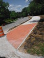
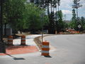
looking north at NC54 - this was previously a narrower pedestrian-only sidewalk
looking south towards the entrance to the bridge
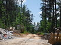
the trail to the bridge, under construction. The pile of rubble on the left is visible on the right side of the previous photo.


Documents
- 2011-01-07 ATT Phase E Update from the City of Durham: waiting for "Erosion Control Permit" (submitted 1/5) and North Carolina Department of Environment and Natural Resources approval (submitted 1/3), with a 60-day approval cycle anticipated for both.
- 2010-10-22 ATT Phase E Update from the City of Durham
Links
- 2012 American Tobacco Trail and Bridge (SW-24): official project page
- 2012-05-31 Portion of Tobacco Trail to close for 1 year
- American Tobacco Trail Project - Phase E from N.C. 54 South to the Chatham County Line Trail and Pedestrian Bridge over I-40 (via archive.org)