Difference between revisions of "American Tobacco Trail/I-40"

from HTYP, the free directory anyone can edit if they can prove to me that they're not a spambot
Jump to navigation Jump to search
(Created page with '==About== Crossing I-40 to between sections of the American Tobacco Trail will be a bit tricy until the pedestrian bridge is built. ===Fayetteville Road=== Th…')
 
(Jack Warman's night/lighting photo)
 
(10 intermediate revisions by the same user not shown)
Line 1: Line 1:
 +
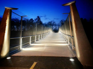
[[File:Jack-Warman-ATT-bridge.jpg|thumb|the bridge at night, showing newly-installed lighting]]
 +
==Navigation==
 +
* '''north''': {{l/same|south Durham}}
 +
* '''south''': {{l/same|south of I-40}}
 
==About==
 
==About==
Crossing [[I-40]] to between sections of the [[American Tobacco Trail]] will be a bit tricy until the [[/bridge|pedestrian bridge]] is built.
+
The crossing over [[I-40]] was the major obstacle, for many years, to having a contiguous [[American Tobacco Trail]], but the long-awaited [[/bridge|pedestrian bridge]] was finally opened on 2014-02-20, connecting the {{l/same|south Durham}} stretch with the stretch {{l/same|south of I-40}}, itself completed in 2013.
===Fayetteville Road===
 
The "obvious" way across [[I-40]] is to get onto [[US/NC/Durham/roads/Fayetteville|Fayetteville Road]] and cross with the traffic. This is tricky, as there are no apparent sidewalks and it is a busy street. One rider reports that you can get across by turning right on 54, crossing at the next street (Rollingwood), then "cutting through the Harris Teeter shopping center and then turning right onto Fayetteville Rd. to cross I-40. That crossing looks like a monster but it is actually quite safe if you take it in pieces. The intersection is so complex that there are plenty of islands in which a cyclist can wait for a favorable traffic pattern. From there I take Fayetteville south past [[Southpoint Mall|the mall]] which is busy but four lanes wide so cars can pass me if they need to, or sometimes I go through the mall parking lot. Past the mall it's a short scoot to Massey Chapel on the right", which leads to the next segment of the ATT.
 
===Highway 751===
 
''this detour was discovered independently by {{thehypertwins}} on 2007-08-01, though apparently [http://blogs.newsobserver.com/joemiller/index.php?title=bridging_the_att_in_durham_minus_the_bri&more=1&c=1&tb=1&pb=1 others] have discovered it as well''
 
  
A somewhat less alarming crossing is at the next bridge to the west ([[NC 751|Highway 751]]), which has a sidewalk. The way to get there is relatively pleasant (sidewalks available most of the way) and does not involve riding with any busy traffic:
+
The pedestrian bridge as well as the portions of trail connecting it northward to the former "temporary end" on [[NC 54]] and southward to the far side of Massey Chapel Road are officially known as "Phase E" of the ATT.
* Turn right on [[NC 54]] (stay on the sidewalk, if you value your life)
+
 
* At the next street ('''Rollingwood''' on your right, '''Highgate Drive''' on the left, across the street), cross 54 (there's no crosswalk or pedestrian signal, so you have to wait for the traffic light and watch for vehicles turning from the cross-street; this seems to be the most dangerous point of the trip.)
+
* [[/bridge]]: information about the pedestrian bridge
* '''Point of interest''': The planned location for the future [[/bridge|bridge over I-40]] is apparently up a short, steep hill just behind the shopping center.
+
* [[/alternate]]: other ways to get between sections
* Continue down Highgate for a couple of bends. Parts of it have no sidewalk, but it's pretty wide and uncongested most of the time
+
==Phase E photos==
* Turn left on '''Audubon Lake Drive''' (if you get back to 54, you've gone too far)
+
<gallery>
* At some point -- the traffic circle is probably a good place -- get onto the left-hand sidewalk. (Actually, we get on the right-hand one, even though that means crossing the road again later... but it makes it easier to ride with the traffic when going downhill towards 751.)
+
File:DSCF0538.JPG | looking north at NC54 - this was previously a narrower pedestrian-only sidewalk
* Continue on [[Southpoint Auto Park Boulevard]] through a lot of soon-to-be-developed wasteland (all with very nice sidewalks)...
+
File:DSCF0540.JPG | looking south towards the entrance to the {{l/sub|bridge}}
* '''Point of interest''': Just past the first of the car dealerships, and past a small lake, there is an old [[Trice Plantation Cemetery|family graveyard]] under a small grove of magnolias at the top of a hill, with graves dating back to the mid-1800s. (There is also a paved footpath beginning right next to the graveyard; it goes down to the lake and around it, and emerges just to the west of the car dealership. It appears both fairly new and not well-maintained, as there was a large tree-branch blocking the graveyard-side trail entrance for several months in the summer of 2007, and a lot of leaves on that portion of the trail.)
+
File:DSCF0549.JPG | the trail to the bridge, under construction. The pile of rubble on the left is visible on the right side of the previous photo.
* Continue past both of the mondo new car dealerships and out to '''Hope Valley Road''' ([[NC 751]]). The car traffic picks up a bit as you get into car dealer territory, and sometimes there are people mowing with rider mowers and blocking the sidewalk.
+
</gallery>
* Turn left onto 751 / Hope Valley Rd. Again, I advise using the sidewalk even though it is not marked for bicycle use; it does not seem to be used by pedestrians, and if the police give you a hard time for riding on the sidewalk, tell them I said it's ok. ^_^
+
==Documents==
* This takes you across I-40, including the westbound exit ramp and the eastbound on-ramp. I have to assume you know how to handle yourself in weird car-bike situations, but do be careful. The good thing is that the sidewalk continues across the bridge and all the way to '''Renaissance Parkway''', which is the entrance to the [[Southpoint Mall]] area and is also lined with sidewalks and what looks like an actual bike trail on the far (south) side.
+
* '''2011-01-07''' [http://www.durhamnc.gov/departments/works/pdf/att_update010711.pdf ATT Phase E Update] from the City of Durham: waiting for "Erosion Control Permit" (submitted 1/5) and North Carolina Department of Environment and Natural Resources approval (submitted 1/3), with a 60-day approval cycle anticipated for both.
* Turn (left) into Renaissance Parkway, then right on Leonardo, left on Morrell Lane. Loop around until you start back uphill, then turn left onto Crichton Lane, which ends at a cul-de-sac. On the east side of the cul-de-sac is a wooden stairway which leads down to a well-traveled sewer right-of-way which connects to a tiny piece of the former railroad right-of-way, from which you can access Massey Chapel Road and the official recommencement of the ATT.
+
* '''2010-10-22''' [[:File:ATT Update 2010-10-22.pdf|ATT Phase E Update]] from the City of Durham
** Although there are stubs of the ATT where it crosses Renaissance Parkway, neither of these is particularly useful until the connectors are finished; on the north side (will eventually connect to the pedestrian bridge) you bump into I-40, and on the south side you end up in a swamp.
+
==Links==
** Some maps show the future ATT following the sewer right of way, while some show it keeping to the other side of the swamp. We hope that if it does end up crossing the swamp, they put up a boarded bridge rather than paving it...
+
* [http://durhamnc.gov/ich/op/pwd/consproj/Pages/SW-24-ATT.aspx 2012 American Tobacco Trail and Bridge (SW-24)]: official project page
 +
* '''2012-05-31''' [http://abclocal.go.com/wtvd/story?section=news/local&id=8683203 Portion of Tobacco Trail to close for 1 year]
 +
* [http://web.archive.org/web/20110721035538/http://www.durhamnc.gov/departments/works/project_am_tob_trail.cfm American Tobacco Trail Project - Phase E from N.C. 54 South to the Chatham County Line Trail and Pedestrian Bridge over I-40] (via archive.org)

Latest revision as of 18:48, 10 April 2014

the bridge at night, showing newly-installed lighting

Navigation

About

The crossing over I-40 was the major obstacle, for many years, to having a contiguous American Tobacco Trail, but the long-awaited pedestrian bridge was finally opened on 2014-02-20, connecting the south Durham stretch with the stretch south of I-40, itself completed in 2013.

The pedestrian bridge as well as the portions of trail connecting it northward to the former "temporary end" on NC 54 and southward to the far side of Massey Chapel Road are officially known as "Phase E" of the ATT.

  • /bridge: information about the pedestrian bridge
  • /alternate: other ways to get between sections

Phase E photos

Documents

  • 2011-01-07 ATT Phase E Update from the City of Durham: waiting for "Erosion Control Permit" (submitted 1/5) and North Carolina Department of Environment and Natural Resources approval (submitted 1/3), with a 60-day approval cycle anticipated for both.
  • 2010-10-22 ATT Phase E Update from the City of Durham

Links