Difference between revisions of "American Tobacco Trail/I-40"
(extracted workaround to subpage; added subpage for bridge) |
(Phase E photos) |
||
| Line 9: | Line 9: | ||
* [[/alternate]]: workarounds until the bridge is available | * [[/alternate]]: workarounds until the bridge is available | ||
* [[/bridge]]: information about the pedestrian bridge | * [[/bridge]]: information about the pedestrian bridge | ||
| + | ==Phase E photos== | ||
| + | <gallery> | ||
| + | File:DSCF0538.JPG | looking north at NC54 - this was previously a narrower pedestrian sidewalk | ||
| + | File:DSCF0540.JPG | looking south towards the entrance to the {{l/sub|bridge}} | ||
| + | File:DSCF0549.JPG | When complete, this will be the trail to the bridge. The pile of rubble on the left is visible on the right side of the previous photo. | ||
| + | </gallery> | ||
==Documents== | ==Documents== | ||
* '''2011-01-07''' [http://www.durhamnc.gov/departments/works/pdf/att_update010711.pdf ATT Phase E Update] from the City of Durham: waiting for "Erosion Control Permit" (submitted 1/5) and North Carolina Department of Environment and Natural Resources approval (submitted 1/3), with a 60-day approval cycle anticipated for both. | * '''2011-01-07''' [http://www.durhamnc.gov/departments/works/pdf/att_update010711.pdf ATT Phase E Update] from the City of Durham: waiting for "Erosion Control Permit" (submitted 1/5) and North Carolina Department of Environment and Natural Resources approval (submitted 1/3), with a 60-day approval cycle anticipated for both. | ||
Revision as of 20:44, 19 May 2013
- north: south Durham
- south: south of I-40
About
Crossing I-40 between sections of the American Tobacco Trail will be a bit tricky until the pedestrian bridge is built and the trail-stub currently in place is connected to the next section. (According to Google Maps, the latter has already been done, but I have not verified this in person. --Woozle (talk) 16:31, 19 May 2013 (EDT))
The pedestrian bridge as well as the portions of trail connecting it northward to the "temporary end" on NC 54 and southward to where the trail resumes on the far side of Massey Chapel Road are officially known as "Phase E" of the ATT.
- /alternate: workarounds until the bridge is available
- /bridge: information about the pedestrian bridge
Phase E photos
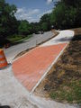
looking north at NC54 - this was previously a narrower pedestrian sidewalk
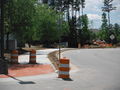
looking south towards the entrance to the bridge
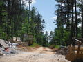
When complete, this will be the trail to the bridge. The pile of rubble on the left is visible on the right side of the previous photo.


Documents
- 2011-01-07 ATT Phase E Update from the City of Durham: waiting for "Erosion Control Permit" (submitted 1/5) and North Carolina Department of Environment and Natural Resources approval (submitted 1/3), with a 60-day approval cycle anticipated for both.
- 2010-10-22 ATT Phase E Update from the City of Durham